After The Construction Project Completes, How Long Does The Website With Deliverables Remain Online? For 90 days after the last drone flight has occurred. If you would like to keep a website up that shows the construction process, Above and Beyond Imagery can assist with that for a fee.
After The Construction Project Completes, How Long Do The Deliverables Remain Available To Download From Your Cloud? For 90 days after the last drone flight has occurred. We would like to be able to keep imagery saved on file for as long as possible, but the truth be told high resolution stills, video, and orthomosaics take up a lot of memory, and storage costs add up over time. It is best to download all files as they become available from our drone flights.
How Often Do You Fly The Construction Site To Capture Imagery? That is up to the customer. The average being reported in the industry is twice per month, but that really depends on the construction site and work being done. We will fly every day, a few times per week, bi-monthly, or monthly – whatever the customer requests. Flying a site more often does save money per flight.
Does Weather Affect Drone Flights? Yes, it certainly does. Sprinkles, rain, fog, snow, temperatures below freezing, and gusting winds over 25mph will often result in a drone flight being postponed or possibly flown early. We always try and keep an eye on the weather and how it may affect a drone flight. It may not be raining, but even a thunderstorm cloud displaying lighting ten miles away is often enough to postpone a drone flight. For more information please refer to our Postponed Flights page.
How Much Does Drone Construction Progress Monitoring Cost? We charge based on an hourly rate for time involved in pre-flight preparations, on site drone flying, post flight processing, and how often the construction site is being flown. Only about 30 to 40 percent of the work being done is at the construction site flying the drones. The remainder of that time is spent in the office doing pre and post flight work.
Above and Beyond Imagery provides free quotes for our tiered services listed below:
Tier One: Basic aerial still photography. This is our lowest tier and most basic drone service for constriction site progress monitoring. We will fly both automated and manual flights around the construction area to capture still photos of the overall construction site.
Tier Two: Includes Tier One still photography, but adds videography to the services performed. We will fly both automated and manual flights around the construction area to capture videos of the overall site.
Tier Three: Includes both Tier One and Tier Two and adds photogrammetry/orthomosaic mapping. Orthomosaics can be used to give an overall view of the entire construction site, provide a means of relative accuracy for measurements, stockpile volumetric measurements, and more.
Or Pick and Choose: You may only want still photos captured, or maybe you only need an orthomosaic provided every several days. Perhaps one week you need an ortho only, and then next week you want an ortho plus still imagery… whatever you want we can provide and quote as need.
In order to provide a quote we will need to get some details about the construction site: size, what areas need to be documented, and how often we would be needed to fly the site. We will also need to visit the site and likely fly a drone or two. From there we can provide a “cost per flight” quote. Of course costumers may have additional requests made at a later date that shorten or extend the original estimated flight time, and that would affect the cost per flight.
CLICK HERE TO CONTACT US FOR A FREE QUOTE REQUEST
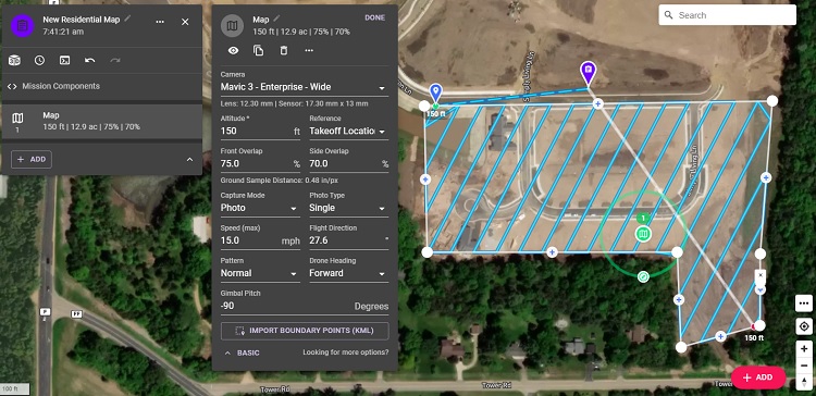
Are Your Flights Flown Manual Or With Pre-Programmed Automation? The quick is answer is to say we do both. The long answer is this: most of the flights are programmed in the office at Above and Beyond Imagery and flown using automation on site. This allows for continuity between the flights, which makes it easier for developers and contractors to easily jump back and forth between the days flights occurred to view specific areas if needed. However, we also fly a great deal of manual stick in order to catch additional imagery as needed. Below is an example of a completed programmed flight.
For more information please refer to our main website and content page for Construction Time Lapse Progress Monitoring.
You can also reach for more information through our Contact page.